


Voting District 090201, Warren County, New York
About
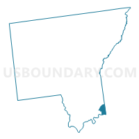
Outline

Summary
| Unique Area Identifier | 638159 |
| Name | Voting District 090201 |
| County | Warren County |
| State | New York |
| Area (square miles) | 4.39 |
| Land Area (square miles) | 4.31 |
| Water Area (square miles) | 0.08 |
| % of Land Area | 98.08 |
| % of Water Area | 1.92 |
| Latitude of the Internal Point | 43.33425990 |
| Longtitude of the Internal Point | -73.61361340 |
Maps


Graphs
Select a template below for downloading or customizing gragh for Voting District 090201, Warren County, New York


Neighbors
Neighoring Voting District (by Name) Neighboring Voting District on the Map
- Voting District 030103, Warren County, NY
- Voting District 030202, Warren County, NY
- Voting District 030203, Warren County, NY
- Voting District 030204, Warren County, NY
- Voting District 090105, Warren County, NY
- Voting District 090202, Warren County, NY
- Voting District 090204, Warren County, NY
- Voting District 130001, Washington County, NY
- Voting District 130004, Washington County, NY
- Voting District 130009, Washington County, NY
- Voting District 140004, Saratoga County, NY
Top 10 Neighboring County Subdivision (by Population) Neighboring County Subdivision on the Map
- Queensbury town, Warren County, NY (27,901)
- Moreau town, Saratoga County, NY (14,728)
- Glens Falls city, Warren County, NY (14,700)
- Kingsbury town, Washington County, NY (12,671)
Top 10 Neighboring Place (by Population) Neighboring Place on the Map
Top 10 Neighboring Unified School District (by Population) Neighboring Unified School District on the Map
- Queensbury Union Free School District, NY (22,046)
- South Glens Falls Central School District, NY (19,546)
- Hudson Falls Central School District, NY (15,389)
- Glens Falls City School District, NY (15,095)
- Glens Falls Common School District, NY (2,325)
Top 10 Neighboring State Legislative District Lower Chamber (by Population) Neighboring State Legislative District Lower Chamber on the Map
Top 10 Neighboring State Legislative District Upper Chamber (by Population) Neighboring State Legislative District Upper Chamber on the Map
Top 10 Neighboring 111th Congressional District (by Population) Neighboring 111th Congressional District on the Map
Top 10 Neighboring Census Tract (by Population) Neighboring Census Tract on the Map
- Census Tract 706.01, Warren County, NY (5,701)
- Census Tract 803, Washington County, NY (5,390)
- Census Tract 601.02, Saratoga County, NY (5,011)
- Census Tract 801, Washington County, NY (4,809)
- Census Tract 704, Warren County, NY (3,731)
- Census Tract 707.01, Warren County, NY (3,655)
- Census Tract 705, Warren County, NY (2,501)
- Census Tract 802, Washington County, NY (2,472)